CONSULTING ENGINEERS AND SURVEYORS
522 SEA ISLE BOULEVARD
OCEAN VIEW, NEW JERSEY 08230-1081
PHONE: (609) 624-1944 FAX: (609) 624-1994
OCEAN VIEW, NEW JERSEY 08230-1081
PHONE: (609) 624-1944 FAX: (609) 624-1994
GIBSON ASSOCIATES, P.A.
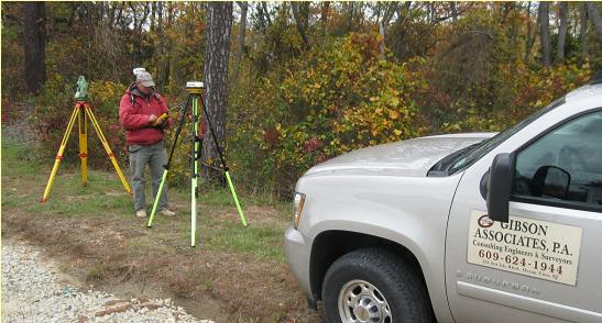
Surveying

Gibson Associates, P.A. utilizes two and three man survey crews to perform field data collection for topographic and boundary surveying services. We use electronic total station instruments as well as Global Positioning System (GPS) equipment to gather field data efficiently and accurately within the mapping standards of the industry. Our surveying department is fully equipped with 4 GPS static receivers and a GPS backpack unit, 2 Lecia Total Stations, Topcon total station, and 3 conventional auto levels.
All data collection is compatible with AutoCAD and Microstation drafting programs. We also utilize aerial photography sub consultants for large tract surveys and base mapping combined with conventional surveying traverses. Survey work includes records research, information and field data acquisition, analysis, boundary resolution and determination, GPS survey planning and resolution, Right of Way (ROW) mapping and parcel acquisition, minor subdivisions, FEMA flood elevation certificates, Metes and Bounds (legal) descriptions, ALTA-ACSM land title surveys, large boundary surveys, topographic surveys, bathymetric surveys, construction layout (residential & large commercial buildings, utilities, site grading), wetland locations, and any additional survey work as needed to support civil engineering and land development projects.